Fort Facts
Name: Sarasgad
Type: Hill Fort
Height: 490 metres
District: Raigad
Base Village: Pali
Route Options:
1. Pune to Pali MSRTC Bus:
Approx. Cost : Rs. 182 per ticket.
2. Pune - Lonavala - Khopoli - Pali:
Pune-Lonavala local ticket: Rs. 12.
Lonavala-Khopoli Taxi: Rs. 30 per person.
Khopoli to Pali MSRTC bus: Rs. 151.
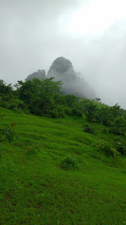
Sarasgad is a fort located in the town of Pali. The town of Pali is famous for playing host to one of the eight Ashtavinayak temples in Maharashtra. The Ashtavinayak temples are famous amongst the devotees of the elephant God Ganesha.
We took the 7 am bus to Roha from the Shivajinagar Bus Station in Pune. To get to Pali from Shivajinagar by bus it took us exactly 4 hours. We had breakfast in a small hotel in Pali, and started walking towards the route.
The route to Sarasgad starts about 500 metres from the Ballaleshwar Temple entrance. If you have trouble finding the route you can ask any of the villagers who will point you in the right direction. At the start of the route, you can see a board with the map of the fort.
The first part of the route follows a stream’s path. The path is well trodden and there aren’t many places you can get confused. Some parts of the path have yellow arrows drawn on rocks to show the right path going up to the fort.

After climbing through the stream, you’ll come up to a path which is perpendicular to the one you came from. You’ll be able to see a large boulder which has an arrow drawn on it pointing to the right. Keep following this path. 10-15 minutes later (depending on your speed), you’ll come to a large fork devoid of any directional arrows. While both roads lead to the same path, the left path is more well trodden than the right one.
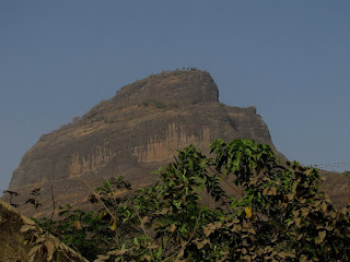
At the end of this path you’ll come to an open area. You’ll be able to see Sarasgad in front. Here onward, all you have to do is stick to the path and make sure that you’re walking towards the fort. If you do that, you have little chance of getting lost.
After clearing the wooded area, keep moving towards the fort. After climbing for another 15-20 minutes or so, you’ll reach right next to the main part of the fort. This is where you’ll see some rough step like features in the rock. Climbing these will get you up to a small flat area which has a small cave carved into the rock.
Right next to this cave are the steps which go up to the Main Doorway of the fort. These steps can be quite slippery in the monsoon, so make sure to take care if you’re visiting during that time. You will have to climb approximately a 100 steps* to reach the Dindi Darwaja, which is the first main door of the fort. The steps are around 2 feet high which might give some trouble while ascending or descending.
As you climb the stairs you’ll notice two bastions at the top of the staircase. At the end of the staircase there is a small flat area with the Dindi Darwaja on your left. As you move through the door, you can see some room like structures. The guards of the fort may have used these for shelter.
Climb the remaining stairs to reach the fort. From here, there are two ways. The path on the left will take you up to the citadel of the fort. The path on the right will take you to a water tank and some caves located at the base of the citadel.
The left way further splits into two, both of which join up later right below a small rock patch to get to the citadel. Reportedly the path on the left fork is easier to navigate, since the one of the right has another small rock patch. But, both paths will take you up to the citadel.
We chose the path on the right. After a gradual climb you will notice a very small patch which you’ll have to climb to get onto the route to the citadel. In about 5 minutes you’ll see another fork in the road. The path on the left is the one we did not choose while coming to the citadel. The path on the right which climbs up, goes to the citadel.
As you climb the path to the citadel, you can see that there is a small water tank which carved right into the rock. Keeping the water tank in front, you can see a small flight of rough stairs, which go up to the citadel. The stairs are quite small and there is some amount of exposure here, be careful when navigating this route.
As you climb the path to the citadel, you can see that there is a small water tank which carved right into the rock. Keeping the water tank in front, you can see a small flight of rough stairs, which go up to the citadel. The stairs are quite small and there is some amount of exposure here, be careful when navigating this route.
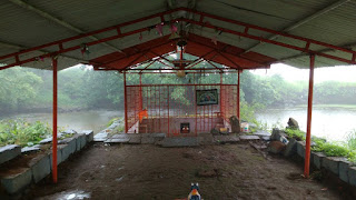
On top of the citadel, there is a small temple dedicated to Lord Shiva (one of the Holy Trinity in the Hindu religion). The temple is located next to a lake. A small water inlet made in the inner sanctum of the temple ensures that the idol stays submerged in water. Besides the temple there’s not much to see on the fort and you can start to make your way down from the fort.
Climbing down, the rock patches on the citadel can be a little risky, especially in the monsoon. Once you reach the Dindi Darwaja, it should not take you longer than an hour to descend to Pali (we did it in half an hour).
Climbing down, the rock patches on the citadel can be a little risky, especially in the monsoon. Once you reach the Dindi Darwaja, it should not take you longer than an hour to descend to Pali (we did it in half an hour).
If you’re travelling by public transport, there is one bus which goes to Pune from Pali which departs from Pali Bus Station at 4 pm. If you miss it (like we did!) there’s a bus going to Khopoli which departs at 5:30 pm and you can take the Lonavala route to get to Pune from there.
Keep trekking!


1 comment:
Everyone loves travelling but most of them avoiding travelling because of high aeroplane tickets. If you are one of them then there is good news for you.Now you can book cheap air flight ticket online through liamtra.
Post a Comment